
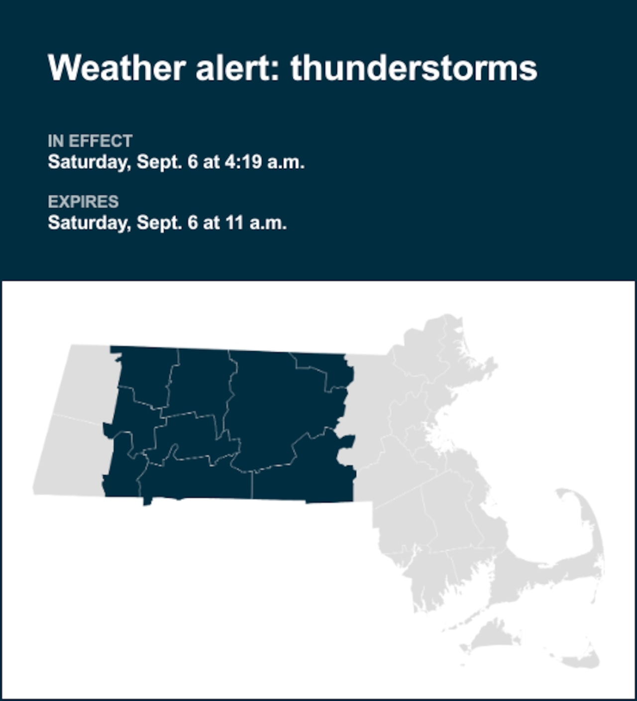
The National Weather Service issued a report at 4:19 a.m. on Saturday for thunderstorms until 11 a.m. for Northern Worcester and Southern Worcester as well as Franklin, Hampshire, Hampden and Middlesex counties.
“A cold front brings potential for scattered severe thunderstorms today to interior southern New England. Thunderstorms may begin to pop-up across eastern New York, along the border with Connecticut and Massachusetts early as 12-2pm. There after is prime time for storms to build develop, between 2-6pm, across the interior of southern New England. Expect thunderstorms to weaken as the line shifts to the I-95 corridor between 7-10pm. Thunderstorms will have the potential to produce straight-line damaging winds, hail, localized flash flooding in urban areas or locations of poor drainage, frequent lightning, and a lower risk of tornadoes. Whether you are heading to an outdoor event or hanging around the house, today is one of those days to remain weather aware, and have multiple ways of receiving weather alerts (cell phone notifications, NOAA Weather Radio, and broadcast meteorologists),” explains the weather service.
Shielding yourself from approaching lightning: Expert safety guidelines
Each year, lightning strikes the United States approximately 25 million times, mostly during the summer. It claims the lives of about 20 people annually, according to the weather service. The threat of lightning becomes more pronounced as thunderstorms draw nearer, peaking when the storm is directly overhead and gradually waning as it moves away.
To ensure your safety during a thunderstorm, consider the following recommendations:
Lightning safety plan:
- When venturing outdoors, it’s crucial to have a lightning safety plan in place.
- Stay vigilant by monitoring the sky for ominous signs and listening for the telltale sound of thunder. If thunder is audible, it’s a clear indication of nearby lightning.
- Seek a safe place to shelter, preferably indoors.
Indoors safety measures:
- Once you’ve found shelter indoors, abstain from using corded phones, electrical appliances, or plumbing fixtures, and refrain from approaching windows and doors.
- These precautions help reduce the risk of electrical surges, as lightning can follow conductive pathways.
Wait for the all-clear:
- After the last lightning strike or thunderclap, wait at least 30 minutes before resuming outdoor activities.
- Lightning can strike even when a storm has seemingly passed, so exercise caution.
When indoor shelter isn’t available:
If you find yourself outdoors without access to indoor shelter during a thunderstorm, take these steps to maximize your safety:
- Avoid open fields, hilltops, or ridge crests, which expose you to greater lightning risk.
- Steer clear of tall, isolated trees and other prominent objects. In wooded areas, stay close to lower stands of trees.
- If you’re in a group, ensure that individuals are spaced out to prevent lightning current from transferring between people.
- Camping in an open setting during a thunderstorm is strongly discouraged. If you have no alternative, set up camp in a valley, ravine, or other low-lying areas. It’s crucial to note that a tent provides no protection against lightning.
- Do not approach water bodies, wet objects, or metal items. While water and metal don’t attract lightning, they conduct electricity effectively and can pose significant risks.
In summary, when facing the threat of lightning, vigilance and preparedness are your best allies. By following these guidelines, you can significantly reduce the chances of lightning-related accidents and prioritize your safety.
Rainy roadways ahead: Essential safety tips for heavy rain
Rain can turn roads into hazards. Stay informed and follow these tips from the weather service to ensure safety during heavy rainfall:
Beware of rapid water flow:
During heavy rain, avoid parking or walking near culverts or drainage ditches, where swift-moving water can pose a serious risk.
Maintain safe driving distances:
Use the two-second rule to maintain a safe distance from the car in front of you and allow an extra two seconds in heavy rain.
Slow down and drive with care:
On wet roads, reducing your speed is crucial. Ease off the accelerator gradually and avoid abrupt braking to prevent skidding.
Choose your lane wisely:
Stick to the middle lanes to minimize the risk of hydroplaning. Outer lanes are more prone to accumulating water.
Prioritize visibility
Enhance your visibility in heavy rain by turning on your headlights. Watch out for vehicles in blind spots, as rain-smeared windows can obscure them.
Watch out for slippery roads:
The initial half-hour of rain is when roads are slickest due to a mixture of rain, grime, and oil. Exercise heightened caution during this period.
Keep a safe distance from large vehicles:
Don’t follow large trucks or buses too closely. The spray created by their large tires reduces your vision. Take care when passing them as well; if you must pass, do so with caution.
Mind your windshield wipers:
Overloaded wiper blades can hinder visibility. If rain severely impairs your vision, pull over and wait for conditions to improve. Seek refuge at rest areas or sheltered spots.
If the roadside is your only option, pull off as far as possible, preferably past the end of a guard rail, and wait until the storm passes. Keep your headlights on and turn on emergency flashers to alert other drivers of your position.
In the face of heavy rain, these precautions can make a significant difference in ensuring your safety on the road. Remember to stay informed about weather conditions and heed guidance from local authorities for a secure journey.
Advance Local Weather Alerts is a service provided by United Robots, which uses machine learning to compile the latest data from the National Weather Service.
If you purchase a product or register for an account through a link on our site, we may receive compensation. By using this site, you consent to our User Agreement and agree that your clicks, interactions, and personal information may be collected, recorded, and/or stored by us and social media and other third-party partners in accordance with our Privacy Policy.


