A Nor’easter barreling into Massachusetts on Wednesday is predicted to bring gusty winds, prolonged rainfall and a chance for significant snowfall in elevated parts of the state — with up to a foot in some areas — making it seem like winter never left.
Rain will spread east as the day goes on, with the precipitation turning to sleet in higher elevations north of the Massachusetts Turnpike. As day turns to night, the storm will bring “locally heavy wet snow over higher elevations, strong to damaging northeast wind gusts, heavy rainfall which could lead to renewed river flooding concerns, and coastal flooding,” according to forecasters with the National Weather Service.
The real impacts of the storm will come overnight when temperatures drop low enough that rain and sleet turn to snow, potentially making for a difficult Thursday morning commute. Forecasters say they are expecting totals of 6 to 12 inches in the northern Berkshires, 3 to 6 inches in the southern Berkshires, and between 4 and 8 inches in the northern Worcester Hills. For the rest of the state, totals will be significantly lower and most of the precipitation will fall as rain, but 1 to 2 inches of snow could fall in and around Worcester and Lawrence.
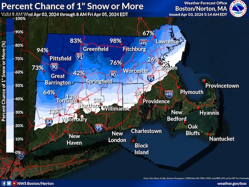
A National Weather Service map shows what areas of the state could see snow during a late season Nor’Easter Wednesday.National Weather Service
“The heaviest snow is expected to fall tonight, which combined with strong winds, will lead to very hazardous travel and isolated power outages,” forecasters warned.
The weather service has set down a winter storm warning for the Berkshires and northern Worcester and Middlesex Counties, with a high wind warning in place along coastal areas including Boston and the Cape and Islands.
“This is expected to be a long-duration, multi-faceted event,” forecasters warned. “While precipitation starts today, intensity will increase tonight into Thursday when some of the heaviest rates may fall accompanied by strong, gusty winds. Be prepared for a prolonged duration of impact.”
Looking ahead, the storm will make its presence felt even after the precipitation dissipates, bringing with it a cold snap expected to bring temperatures down to what might be expected in February, not April, according to AccuWeather Senior Meteorologist Alex Sosnowski.
“It may take until the latter part of the weekend to early next week before the storm pivots far enough to the east to allow gusty winds and cold air to diminish in the region,” Sosnowski wrote.