For the most part, Wednesday will be the calm before the storm across Massachusetts as residents of the Bay State can expect a relatively dry day before a winter storm settles in.
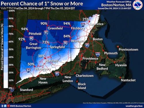
It’s not until after 9 p.m. Wednesday that the bulk of the snow is set to arrive in Western Massachusetts and Connecticut, according to National Weather Service forecasters. But when the snow does arrive, it’s expected to make an impact: up to 6 inches are possible.
In higher elevations like the Berkshires and the Worcester Hills, snow totals should range between 3 inches and 6 inches. In lower areas along the interior of the state, totals will be lower, between 1 inch and 4 inches. The snow will largely bypass the eastern part of the state, with rain expected near Interstate 95.
The snow is expected to continue on Thursday, and forecasters say to expect widespread precipitation between 10 a.m. and 2 p.m.
A Winter Weather Advisory is in effect from 8 p.m. Wednesday to 10 a.m. Thursday and forecasters say commuters should prepare for slippery conditions on the road.

A National Weather Service map shows the chances of an inch or more of snow in Massachusetts. (National Weather Service)National Weather Service
Forecasters also warned of high winds on Cape Cod and the Islands, with gusts between 35 mph and 50 mph. The gusty conditions are expected to continue beyond the Cape on Thursday night, bringing in a colder airmass that could see low temperatures fall into the teens.
“The general theme through Sunday is lower than normal temperatures, both during the day and overnight,” forecasters wrote. “Highs Friday are also likely to not get out of the mid to low 30s, and overnight lows could soundly be in the teens, aside from the coastlines which will sit in the low 20s.”


