
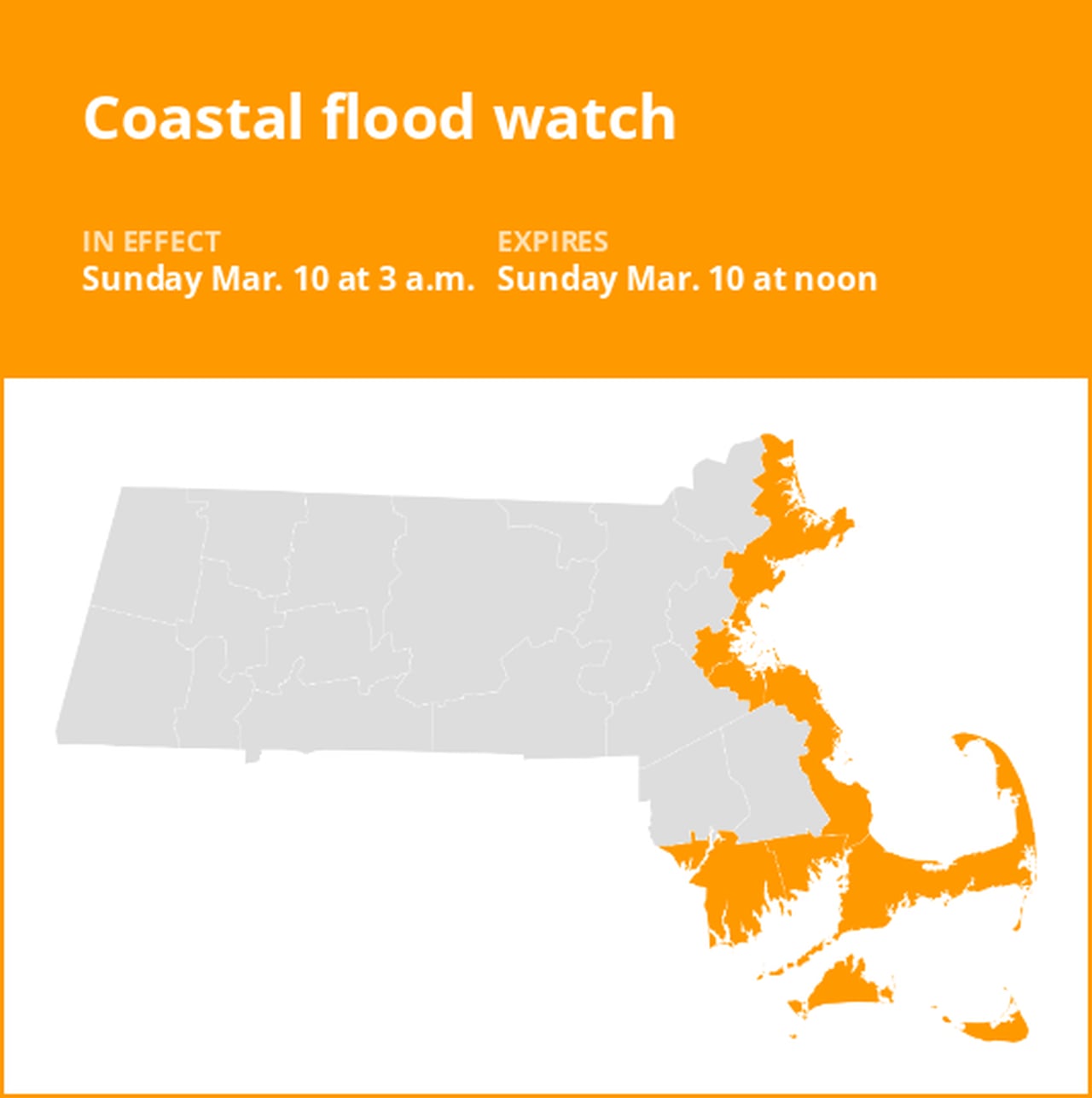
A coastal flood watch was issued by the National Weather Service on Friday at 12:52 a.m. valid for Sunday between 3 a.m. and noon for Essex, Suffolk, Norfolk, Plymouth, Bristol, Barnstable, Dukes and Nantucket counties.
The weather service describes, “One to two feet of inundation above ground level possible in low-lying areas near shorelines and tidal waterways (4.1 to 14.1 feet Mean Lower Low Water).”
“Some vulnerable coastal roads become impassable around high tide. Flooding 1 to 2 feet deep affects some coastal roads and low-lying areas from Revere and Winthrop through Boston to Hull, Braintree, and Quincy. Splashover and debris may wash onto coastal roads when large waves occur. Roads remain passable. Shallow pockets of flooding less than one foot deep affect more vulnerable coastal roads alog the North Shore from Salem and Gloucester to Newburyport. Rough surf will likely cause some splashover onto coastal roads around the time of high tide. Roads remain passable. Low-lying areas and roads near Nantucket Harbor, including Easy Street, may experience pockets of shallow flooding less than one foot deep. Minor flooding can be expected across low-lying areas of Newport, Middletown and Portsmouth. Several immediate coastal roads will be impassable for a few hours around time of high tide. Minor beach erosion on the south side of Newport is possible. Roads remain passable. Shallow pockets of flooding less than one foot deep affect low-lying areas in Provincetown, mainly near the airport and Race Point Road. In Truro, flooding up to one foot deep affects low-lying areas near Pamet Harbor and along the Pamet River. Roads remain passable with pockets of shallow flooding less than one foot deep. This mainly affects low-lying areas and roads near Edgartown Harbor, including the Chappy Ferry Dock. Shallow flooding may also approach Five Corners in Vineyard Haven,” comments the weather service. “If travel is required, allow extra time as some roads may be closed. Do not drive around barricades or through water of unknown depth. Take the necessary actions to protect flood-prone property.”
Your guide to weather alerts: Advisories, Watches, and Warnings
- Flash flood warning: Take action!
A flash flood warning is issued when a flash flood is either imminent or already occurring. In flood-prone areas, it’s crucial to move immediately to higher ground. A flash flood is a sudden and violent inundation that can develop within minutes to hours, and it can even happen in areas not currently experiencing rainfall.
- Flood warning: Take action!
A flood warning is issued when flooding is imminent or occurring.
- Flood advisory: Be aware:
A flood advisory is issued when flooding is not expected to be bad enough to issue a warning. However, it may cause significant inconvenience, and if caution is not exercised, it could lead to situations that may threaten life and/or property.
- Flood watch: Be prepared:
A flood watch is issued when conditions are favorable for flooding. It doesn’t guarantee that flooding will occur, but it signifies that the possibility exists.
Be flood-ready: Expert guidance from the weather service for your safety
Floods can pose a significant threat, especially if you live in a flood-prone area or find yourself camping in a low-lying region. To ensure your safety, the weather service offers essential flood safety guidelines:
1. Seek higher ground:
- If you’re in a flood-prone area, or if you’re camping in a low-lying spot, move to higher ground as a first step.
2. Follow evacuation orders:
- When local authorities issue an evacuation order, promptly comply. Before leaving, secure your home by locking it.
3. Disconnect utilities and appliances:
- If time allows, disconnect your utilities and appliances. This reduces the risk of electrical hazards during flooding.
4. Avoid basements and submerged areas:
- Steer clear of basements or rooms where water has submerged electrical outlets or cords. This helps prevent electrical accidents.
5. Evacuate promptly for safety:
- If you notice sparks or hear buzzing, crackling, snapping, or popping noises, evacuate immediately. Avoid any water that may be charged with electricity.
6. Refrain from walking in floodwaters:
- Never attempt to walk through floodwaters. Even just 6 inches of swiftly moving water can forcefully knock you off your feet.
7. Seek high ground if trapped:
- Should you become trapped by moving water, reach the highest point possible and dial 911 to contact emergency services.
When heavy rain occurs, there is a potential for flooding, particularly in areas that are low-lying or prone to floods. It is crucial to never drive through water on the road, even if it appears shallow. According to the NWS, as little as 12 inches of fast-flowing water can carry away most vehicles. Stay safe by being prepared and informed.
Advance Local Weather Alerts is a service provided by United Robots, which uses machine learning to compile the latest data from the National Weather Service.


