Spring may have sprung, but parts of Massachusetts are likely to see a return of winter weather as soon as early Saturday morning.
In Boston and Eastern Massachusetts, the weather service said there is a chance of snow showers around 2 a.m. Saturday, mixing with rain after 3 a.m. The rain and snow showers are expected to continue until around 8 a.m. when the snow turns to rain. A similar pattern could play out early Sunday morning, with a chance of rain and snow after 4 a.m.
But, even if snow falls in the city, little or no accumulation is anticipated.
The chance of snow is greater in Worcester and Central Massachusetts, where the weather service said snow was likely to fall after 4 a.m. Saturday with accumulations of less than half an inch possible. As Saturday turns into Sunday, the weather service anticipates a chance of rain and snow between midnight and 1 a.m., with a chance of snow after 1 a.m. New snow accumulations of less than half an inch are also possible Sunday morning.
For the western part of the state, the precipitation will be mixed overnight Friday, with rain possibly mixing with snow after 4 a.m. and accumulations of less than half an inch possible. Overnight Saturday, there is a chance for snow between 1 a.m. and 2 a.m., according to the weather service, but little chance of accumulation.
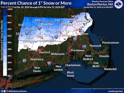
A National Weather Service map shows where Massachusetts residents can expect snow to fall this weekend.National Weather Service
The chance of snow is greatest in the Berkshires, where the weather service said flakes would fall beginning around 2 a.m. Saturday before turning to rain around 11 a.m. Accumulations of less than an inch is possible in the region.
On Saturday night, there is a chance of rain and snow falling before 11 p.m., before the precipitation turns to snow, which is expected to last until about 2 a.m. New precipitation amounts between a tenth and a quarter of an inch are possible in the area, the weather service said.
Whipping winds
On Thursday, forecasters set a wind advisory for much of Wester Massachusetts that stretches until Thursday evening, as the state braces for wind gusts moving as quickly as 40 mph, and up to 50 mph in the Berkshires.
The advisory, which expires at 8 p.m. Thursday, covers all of Berkshire County as well as other areas in the western part of the state including western Franklin, Hampden and Hampshire counties. Winds of 20 to 25 mph are expected throughout the day in the region, according to the National Weather Service.
The weather service warned that gusty winds would blow around unsecured objects and tree limbs could be blown down, creating a risk of power outages.
“Winds this strong can make driving difficult, especially for high-profile vehicles,” the weather service said. “Use extra caution.”
With the high winds come elevated fire concerns for much of the state, as Massachusetts is experiencing “an anomalously dry airmass for March,” according to the weather service. The elevated risk of fire applies to the entire state for much of the day.

