Massachusetts could be hit with a double dose of extreme heat and severe thunderstorm conditions on Thursday.
This combination of risk factors has pushed forecasters with the National Weather Service to issue several hazardous outlook maps to give an idea of just how tumultuous conditions could get going into the afternoon.
Here are six maps to pay attention to as extreme weather is due to roll in Thursday afternoon.
Forecasters described the heat that is to be expected later Thursday to be “dangerous,” with heat indices could reach between 95 and 100 degrees. From Thursday into Friday, there is an elevated heat risk (indicated below in orange) that’s expected to impact metropolitan areas, including Springfield, just around the southeastern parts of Worcester and throughout most of Eastern Massachusetts. This stretches through most of Rhode Island and Connecticut as well.
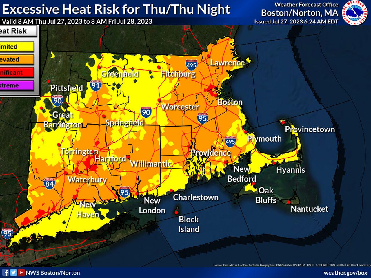
Courtesy of the National Weather Service.
Areas in the map above in yellow can expect a limited heat risk, such as in places like Greenfield and Fitchburg, though both locations are under a heat advisory and are expected to hit high temperatures of 92 and 91, respectively, according to forecasters.
Cities like Boston and Hartford can expect a significant heat risk, as demonstrated above in red. Boston and Hartford could see temperatures reaching 94 degrees, forecasters said.
The heat advisory issued across most of the state went into effect at 11 a.m. on Thursday and will carry on until 8 p.m. Saturday, forecasters said.
Courtesy of the National Weather Service.
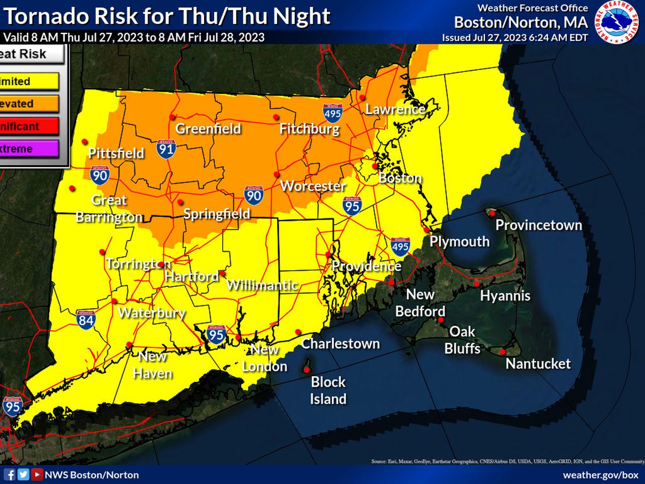
Storm cells are expected to materialize over Western and Central Massachusetts at around 2 p.m., forecasters said. As these storms are expected to shift eastward, it is not clear yet how long storms will stay as cells, therefore extending the risk for brief tornadoes to develop. These storms could clash with another round of storms as they move to the east, potentially affecting the nighttime commute just north of Boston.
“To emphasize,” forecasters said, “this is a severe weather setting which is uncommonly experienced in Southern New England, and the potential for brief tornadoes and straight-line wind damage is a credible risk in environments like this one. If you do have plans outdoors, it’s vital to keep an eye to the sky and to have multiple ways to receive later statements, and that’s especially true in western interior sections of Massachusetts and Connecticut where the greatest potential for severe weather exists.”
Courtesy of the National Weather Service.
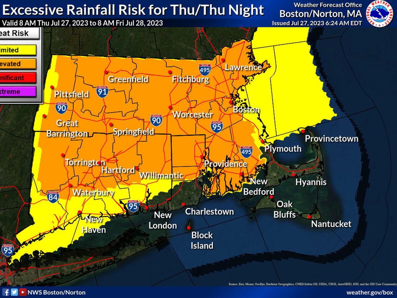
Excluding the Cape, there is an elevated risk for excessive rain across most of Massachusetts, according to the map above. Although rainfall totals in some areas are not expected to go past 1 inch, “these thunderstorms may also produce heavy to excessive rains and given the saturated conditions in place, flooding will again be possible in some locations,” forecasters said.
Rainfall is expected to be between locally heavy to torrential, forecasters said. According to the flood watch, rainfall rates could be between 1 and 2 inches.
Chances for excessive rain also extend down through most of Connecticut and Rhode Island, as seen above.
Courtesy of the National Weather Service.
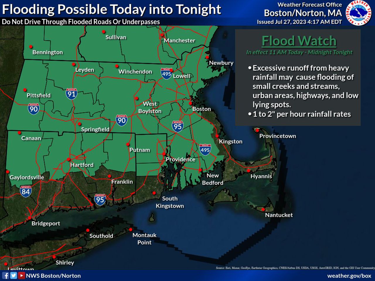
The odds that Massachusetts could see flooding as a result of this extreme weather extends across almost the entire state, excluding the Cape as seen in the map above.
In a flood watch issued by the weather service, creeks and streams could see waters rise out of their banks.
“Flooding may occur in poor drainage and urban areas,” the flood watch said. “…Strong thunderstorms today will be capable of producing heavy rainfall, combined with already saturated soil promotes a flash flood threat for the area.”
Courtesy of the National Weather Service.
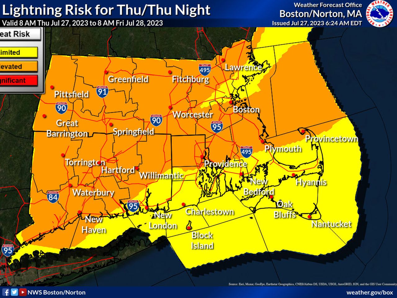
An elevated risk for lightning is also possible for much of Massachusetts and Connecticut. Along with the rain and the potential for damaging winds, forecasters said “frequent cloud to ground lightning (is) the greatest (risk) with thunderstorms.”
The elevated risk extends to all of Western and Central Massachusetts, stretching even towards parts of south Eastern Massachusetts including Plymouth and across the Cape in Provincetown. Communities such as New Bedford, Hyannis and Nantucket see a far more limited risk of lightning striking.
Courtesy of the National Weather Service.
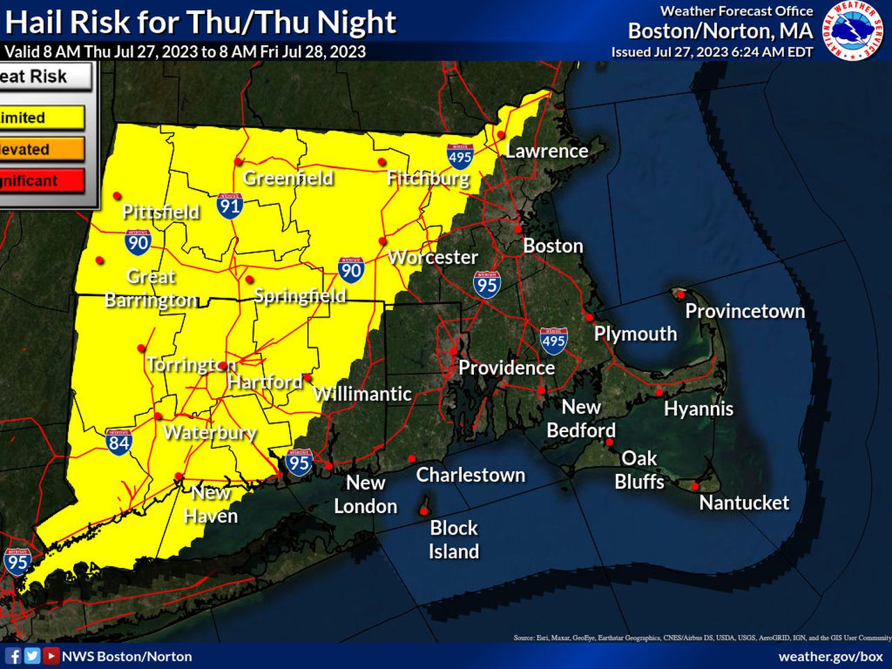
The risk of hail is rather limited, but forecasters warn that it could be possible to see hail over much of Massachusetts and as south as Connecticut going into New York. All of Western Massachusetts and most of Central Massachusetts could see hail develop Thursday, as can Lawrence.
The rest of Eastern Massachusetts, including the Cape and Islands, are not expected to see any hail develop going into Friday.